

Environmental monitoring refers to various activities conducted to obtain knowledge and systematically accompany the situation of natural resources. It is used to help to protect the resources monitored, mitigate impacts and guarantee their sustainable use.
This post explains the productive activities to which environmental monitoring is related, the main forms of conducting monitoring and their advantages, recent innovations and trends in the field and studies about remote sensing for environmental monitoring.
What are the advantages of environmental monitoring from space?
A variety of human and productive activities require environmental monitoring solutions. This is due to legal requirements related to environmental licensing processes for projects, or to environmental compliance issues, when seeking access to distinct markets or to obtain credit and investment.
Examples of activities that frequently require environmental monitoring solutions include mining and manufacturing, civil construction projects (highways, railroads and electrical transmission lines), utility services, agricultural activities and those involving the extraction and use of natural resources (silviculture, forest exploitation).
Environmental monitoring programs are usually conducted in two ways:
(1) based mainly on data collection in the field, with later analyses conducted in a laboratory or office; or
(2) with remote sensing.
While data collection in the field is a more common practice among companies and in projects, this approach consumes a large quantity of human and financial resources and has limitations. Depending on the objective of the monitoring, the related difficulties may include:
- Low spatial and temporal representation in most cases;
- Data collection in an intrusive manner, requiring interaction with the environment monitored; and
- Difficult access that can prevent data collection in locations of interest.
Remote sensing is an optional approach that is already widely used and has strong potential for the development of applications for environmental monitoring. It is conducted using data and images collected by sensors aboard satellites.
Environmental monitoring by Remote Sensing
Environmental monitoring by remote sensing is based on processing data and images acquired by sensors on satellites and other types of platforms, to extract information about targets on the earth’s surface, or processes of interest over time.
It is important to emphasize that monitoring by remote sensing is not applicable to all situations or all those required in highly complex monitoring processes. In some cases, the technique is used to complement conventional monitoring methods. In others, it can completely eliminate the need for field visits and spending on laboratory analyses or those done in an office.
The main advantages of this approach in relation to conventional monitoring are:
- Greater spatial representation of the area monitored;
- Data obtained with greater frequency;
- Coverage of large areas;
- Data collection in a non-intrusive and systematic manner;
- Possibility to acquire information in difficult to access areas;
- Possibility to reduce costs of monitoring programs;
- Greater speed in providing information to decision makers.
Among the applications for images collected by satellite for environmental monitoring we can highlight water-quality monitoring in reservoirs and other water bodies, monitoring of vegetation in areas of direct and indirect impact of projects (areas of mining, highways and energy transmission lines), monitoring of environmental conformity on agricultural properties and others.
Some examples:
Algae bloom in the reservoir of the Tucuruí hydroelectric dam, near the city of Breu Branco, Pará. Observed by Sentinel-2, MSI sensor, 20/04/2017. True color composition R4G3B2:


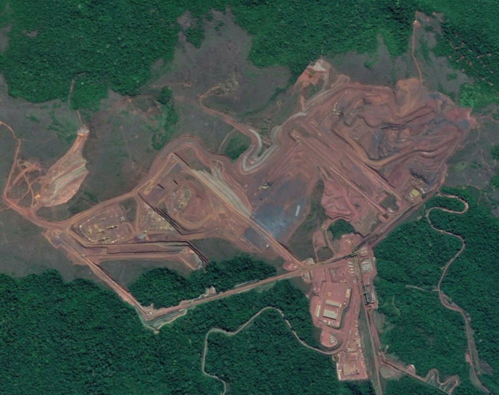
Area of direct impact of mining activity in the region of Carajás, Pará. Observed on 09/07/2017. True color composition. Source: Google Earth:

Advantages of environmental monitoring by Remote Sensing
A very positive aspect in relation to environmental monitoring by remote sensing is the fact that there are now various active satellite missions that publicly or commercially provide data and images with different characteristics and spatial, spectral and temporal resolutions. These missions include:
Landsat of the National Aeronautics and Space Administration (NASA), Sentinel of the European Space Agency (ESA) and CBERS of a Brazil and China partnership, which publicly provide historic series of images collected, in the form of standardized products in georeferenced archives, ready to be consumed by the final user.
Another important aspect is the availability of an increasing number of sensors with different characteristics, which allows the collection of a wide variety of types of data and images, expanding the opportunities for applications for environmental monitoring. The main types of sensors used and their characteristics and applications for environmental monitoring are presented in the chart below:
- Type of sensor Characteristics
- Multi-optical and hyperspectral.
- RADAR (Radio Detection and Ranging)
- LiDAR (Light Detection and Ranging)
Collects information in the visible and near infrared spectral ranges and in short waves. The sun is the main source of energy used in this type of imaging, which can only collect images during the day. The process suffers under certain weather conditions and cannot collect images in cloudy conditions.
Registers the energy issued by the targets on the earth’s surface, and can acquire data day or night.
This is considered an active sensor, and has its own energy sources, and is thus capable of collecting data at night. It registers energy in the microwave range and can collect information regardless of meteorological conditions.
This is considered an active sensor, and has its own sources of energy, and is thus capable of collecting data at night. It can collect information regardless of meteorological conditions.
Examples of Applications
- Monitoring of quantitative aspects of vegetation (such as suppression and regeneration) and qualitative ones (such as detection of species of interest); – Monitoring of water quality; – monitoring of erosive processes.
- Monitoring of fires; – Monitoring of heat islands; – Monitoring of sources of thermal pollution in water bodies.
- Monitoring of biomass and forest carbon; – Monitoring of quantitative and qualitative aspects of vegetation; – Monitoring of movement of masses;
- Monitoring of biomass and forest carbon; – Monitoring of quantitative and qualitative aspects of vegetation;
Main types of sensors, characteristics and applications of environmental monitoring.
Technological trends
In relation to the technological trends in the form of data acquisition with remote sensing we can highlight the advent and intensified use of nanosatellites. These are miniature satellites that can be operated in the form of constellations, expanding the form of imaging of the Earth’s surface in a way never before seen. One successful case is that of the California based company Planet, which operates more than 150 nanosatellites organized in different constellations, and provides data and products in a unique combination of high spatial resolution and frequency of imagining.
In relation to technological trends in data storage and processing we can highlight the availability of the main collections of satellite images in cloud storage and processing services such as Earth on AWS from Amazon and Google Earth Engine, by Google.
The advantages of monitoring solutions based on this type of technology include the ease of manipulation of large volumes of data without a need for file transfer (download), the ability to conduct processing with cloud computing capacity, and the possibility to develop algorithms using widely used machine learning and deep learning platforms (for ex. PyTorch and Tensorflow).
The CERTI staff is capable of developing environmental monitoring solutions using the state-of-the-art processes for the acquisition and processing of satellite data. If you would like to learn more about the projects developed, please contact us at: comercial@certi.org.br